
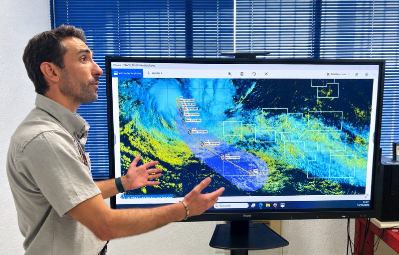
The Tuhaa Pae archipelago “will endure a good storm,” warns Alexis Decalonne of Météo France. “Ahead of” the usual cyclone season, the Wati system is expected to reach the strong tropical depression stage before weakening as it approaches the Austral Islands, Sunday evening. The deputy head of the forecast division “does not completely rule out” that the storm could intermittently reach the cyclone stage, urges preparations for gusts of 100 to 110 km/h, 4 to 5-meter swells and heavy rainfall. And to stay cautious beyond the Austral Islands and Sunday evening: the evolution of the system remains uncertain.
Radio 1: What is the current status of the Wati system and what are the forecasts for the coming days?
Wati is currently at the stage of moderate tropical depression. It should move to the strong tropical depression stage within the next 24 hours, then maintain this intensity until Sunday morning. Thereafter, it will encounter environmental conditions less favorable for development, with somewhat cooler waters and atmospheric conditions that will impede its intensification. It should therefore weaken and return to the moderate tropical depression stage before arriving at the Austral Islands.
What are the main risks for the Austral Islands?
The Austral Islands will experience a good storm starting Sunday in the late afternoon. We expect wind gusts around 100 to 110 km/h, accompanied by rough to very rough seas, with swells of four to five meters, as well as heavy rainfall.
The swell should be relatively short, since it will be mainly generated by the winds directly linked to this disturbance. Conditions could therefore be particularly difficult, especially for nautical activities.
Could the phenomenon still intensify and reach the cyclone stage?
It is precisely the intensification phase over the next 24 hours that we will monitor closely. We need to see whether the system will surpass the strong tropical depression stage. This is not the scenario we are currently favoring, but we remain vigilant.
The possibility that the system could intermittently reach the cyclone stage is not entirely ruled out, even if the probability remains low at this stage. We are therefore closely monitoring its evolution.
Will Wati likely affect the other archipelagos of French Polynesia?
The Austral Islands will be the most affected and will experience the system’s effects for longer, up to late Monday afternoon, or even Tuesday morning. For the other islands of French Polynesia, we do not anticipate significant impact at this stage.
In the Society Islands, we should have fairly extensive cloud cover, with few clear spells. However, we do not expect heavy rainfall or major thunderstorm activity. The Marquesas and the Tuamotu should also remain on the system’s periphery.
What precautions should residents of the Austral Islands take?
People should take protective measures and bring indoors anything that is outside, especially items that could be blown away by the wind. Also, pay particular attention to strong winds and avoid nautical activities when conditions become dangerous.
Authorities will publish the necessary guidance to frame the situation. On our side, we will closely monitor the evolution of the phenomenon and the vigilance levels, which may be adjusted over the coming days.
Wati is the first system of the cyclone season. Is it unusual to see it appear so early?
Yes, we are in a particular context this year, with a particularly intense El Niño episode. The phenomenon developed while the cyclone season in French Polynesia officially begins on November 1st. We are therefore ahead of the usual schedule.
Météo France maintains 24-hour monitoring. We had identified an area conducive to the development of a moderate tropical depression, and when it formed, we organized our service to ensure its tracking. A dedicated forecaster post, staffed from 6 a.m. to 6 p.m., was set up until the end of the phenomenon.
Could the situation also disrupt air traffic in the region?
I cannot answer precisely for all air traffic. We do, however, have regular contacts with the relevant services. Flights to Rarotonga were planned this weekend and are expected to be canceled on Sunday.
The Cook Islands are expected to be much more directly affected by the system, which could reach a higher intensity there. For international flights, airlines can also adjust their routes to avoid the disruption.