
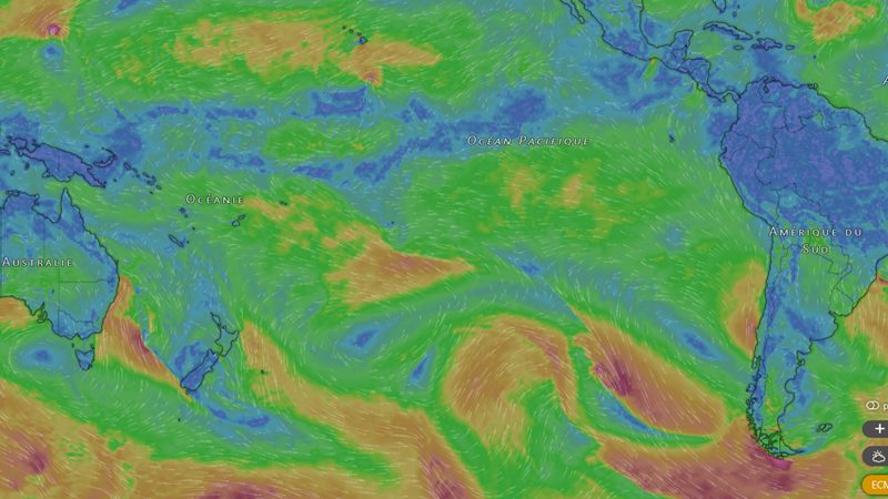
Only one simulation from the American GFS model was enough to set social networks on edge at the start of the week, before the forecasted cyclone disappeared in the next update. To navigate among Windy-type apps, Météo-France advises looking at the forecast horizons, cross-checking the models, and trusting its daily cyclone bulletins. Pages like Infos Cyclones can come in as a “complement,” according to the head of the forecasting division, who recalls that no cyclone threat has been identified for the coming days.
A weather simulation from the American GFS model, which on Tuesday, almost nine days out, envisaged the formation of a strong depression in the immediate vicinity of the Society Islands, with waves reaching up to 9 meters, rattled social networks at the start of the week. A so‑called phantom cyclone that simply vanished in the model’s next update.
For Météo-France, this episode illustrates the high variability of long-range simulations. A scenario that materializes, fades, then returns through updates betrays an uncertainty that remains high. “Beyond three to four days, we start to have relatively average reliability. And beyond seven days, we are often in poor forecast reliability,” notes Patrice Lechanteur, head of the forecasting division at Météo-France.
Internet users who inform themselves with different models
Today, many people consult maps and weather models themselves, without waiting for bulletins. They rely on tools like Windy, which reproduce the same families of models used by meteorologists, notably the American GFS, “a good model” according to Patrice Lechanteur, and the European Centre’s model (CEP), both also offered on Windy. “We look at four to five models on average, or even ten for cyclone forecasting. And you should know that a single model can also have many scenarios,” explains the forecaster, who adds that “these models forecast on many parameters. We, we have slightly finer parameters that allow us to correct them and to produce our forecasts.”
Windy also uses the German ICON, according to Infos Cyclones. For this page that comments on maps intended for the public, the European model remains the reference, especially to identify cyclone trends between Day 6 and Day 10. Its host, Teuira, criticizes the GFS, which shows up to 16 days of forecasts on Windy, for its “troubling tendency to deepen low pressures,” which regularly leads it to conjure up “imaginary monsters” of cyclones at Day 8 or Day 10, such as the one this week. As for ICON, limited to seven days, its view often helps, according to Teuira, to distinguish the other two within the 0–5 day window.
Some tips for reading these models
To interpret these models most effectively, the first reflex, for the head of the forecasting division at Météo-France, is to look at the horizons. The further the cursor advances on Windy, the lower the reliability.
The second tip, and it is key according to Météo-France: you must cross-check the models. “Each model operates with somewhat different processes, which means they do not all produce the same forecasts. In some complex situations, you can have fairly divergent forecasts. This should raise a red flag.”
Infos Cyclones also advises aligning the model with reality by comparing what each model shows for the present moment with what is observed outside. If the sky is dark while a model shows bright sunshine, better to be wary: the model that best matches the present state generally has better “take-up” of the atmosphere and a head start for what comes next.
Informing yourself, yes, but with official sources in reference
These precautions also apply to forecasters. “Forecasting is still very complex here,” acknowledges Patrice Lechanteur. According to him, the public’s access to all this data has an advantage: “Now, when people look at model data, they see that every day it changes, sometimes a lot. They realize the difficulty of forecasting.” Even with training and more precise parameters, “when the model isn’t good, we won’t invent something either.”
For the forecaster, seeking information elsewhere, such as via Infos Cyclones, can constitute a “complement” that “can be useful.” But “the information to prioritize is of course that from the official centers, namely Météo-France here.” “Our role is precisely to try to be as reliable as possible in disseminating our information. And even so, it is not easy,” he adds.
A new daily cyclone bulletin on the Météo-France site
As Météo-France announces a hot season marked by a very strong El Niño and a high cyclone risk, the institution invites readers to consult its new daily cyclone activity bulletin on its site meteo.pf, updated each day in the late afternoon. It comes in the form of a map covering the Polynesian basin for one week, signaling areas where the formation of a moderate tropical depression, the first stage of a possible cyclone, is possible.
“It is therefore a seven-day forecast, and if the risk materializes, at that moment we will produce trajectory maps and cyclone information bulletins, which we also make available to the general public, well in advance so that people have time to prepare for the possible arrival of a phenomenon,” explains Patrice Lechanteur.
A “very, very low” cyclone risk next week
The bulletin issued this Friday afternoon reports no ongoing phenomenon in the South Pacific. It does identify, however, a suspect area that could form off the northeast of Samoa early in the week, with a low probability of cyclogenesis. An area that poses no threat to French Polynesia within the next seven days, according to Météo-France.
For Patrice Lechanteur, the risk is “very, very low,” and if the area has nonetheless been flagged on the map, it is because “we preferred to materialize a small risk that exists,” in the current context. “We have conditions that are starting to become favorable to the north of the country. And we know well that under those conditions a phenomenon can form. So we do not rule anything out,” he adds.
The bad weather, for its part, has settled well over Tahiti and Moorea this weekend. The Wind Islands were placed under orange vigilance for heavy rainfall from Friday, with significant totals and uneven distribution across Tahiti, where the center, the east coast, and the peninsula were mainly drenched in the night from Friday to Saturday.